
Build a Sherwood Address Timeline
Different eras call for different sources. Current and recent ownership starts with the Pulaski assessment roll and online deed index. Earlier title work moves to the clerk's research room. Occupancy depends on reverse directories, annual city directories, and open census schedules. Permits date physical work, while obituaries and probate can explain a household's end or an heir's later transfer.
| Source | Years or era | Where held | What it adds |
|---|---|---|---|
| Assessment roll | Current and recent portal data | Pulaski Assessor / ARCountyData | Owner, situs, mailing address, parcel, deed bridge |
| Online recorded deeds | 1994 to present | Pulaski clerk web search | Transfer parties, dates, instrument, legal description |
| Clerk land-record scans | As early as 1819 | Clerk research area | Deep chain of title before the web cutoff |
| City and reverse directories | Metropolitan collection from 1921 onward | CALS Roberts Library | Dated address and occupant snapshots |
| Federal census | Public through 1950 | NARA and library databases | Household members and enumeration geography |
| Sherwood permits | Modern files; online start not verified | City Permits & Planning / FOIA | Construction date, role labels, contractor, work |
A question about the 2000s can begin online. A nineteenth-century land question cannot. For a mid-century household, land records may identify an owner, but a directory or census is needed to answer who lived here before.
Start Sherwood Previous Residents by Parcel
Search the Pulaski County assessment roll by the current property address. Save the assessed owner, owner mailing address, situs address, parcel number, legal description, subdivision, lot and block, sale date, and any book, page, or instrument reference. The legal description is more durable than a postal label and provides the best safeguard against merging two similar addresses.
A parcel card may also show building type, year built, square footage, values, acreage, property class, and sale history. Those fields help date the property, not its residents. The assessed owner is not an occupant list, and an out-of-town mailing address does not prove where that owner lives. If the portal fails, call the assessor at 501-340-6170 or use the counter or raw-data channel with the street, subdivision, or parcel clue.
Backward flow. Current address → parcel and legal description → latest deed → earlier grantee record → prior owner → dated occupant sources.
Trace Pulaski Deeds Backward
The Pulaski County Real Estate Department holds deeds, mortgages, releases, liens, leases, plats, and other recorded land instruments. Its public website covers 1994 to the present. Search by the current owner's name or an exact instrument reference from the assessor card, open the acquisition deed, and compare its legal description with the parcel.
- Record the current parcel number, legal description, and deed reference from the assessment account.
- Find the current owner's acquisition deed and identify its grantor, grantee, date, instrument, and predecessor citation.
- Search that seller, or grantor, as a grantee in an earlier purchase.
- Match the same legal description, then repeat the process to the web cutoff.
- For earlier years, reserve a research-room terminal and continue through book, page, and party references.
- Grantor
- The party transferring an interest in the recorded instrument.
- Grantee
- The party receiving the recorded interest.
- Chain of title
- The linked sequence of recorded transfers for the same land.
- Legal description
- The lot, block, subdivision, or metes-and-bounds identity used in land records.
A deed chain proves recorded ownership events. It does not show every person who occupied the building between transfers. Keep the owner timeline in one column of the research notes and the household timeline in another.
Cross Sherwood's 1994 Record Boundary
The 1994 web cutoff is an access boundary, not the start of Pulaski County land records. The clerk reports scanned material reaching 1819 in its research area. Older work requires an appointment booked online. Four two-hour slots are offered Monday through Thursday at 8:15, 10:15, 12:15, and 2:15. Appointments cannot be made by telephone or email, are capped at two per week, and use two public computers.
Carry the last web-era book and page into the research room. Then follow predecessor references and grantor-grantee links one instrument at a time. Exact legal descriptions matter because Sherwood did not exist as an incorporated city until 1948. An older land record can be valid even when its heading says rural Pulaski County rather than Sherwood.
Copies and certified records come through the clerk. The index helps locate an instrument, but the image is stronger evidence because addresses, consideration, return-to details, and other clues may appear only in the document.
Note: Book the clerk's research room before traveling; the published procedure does not allow appointment requests by phone or email.
Match Sherwood Residents by Year
After ownership is mapped, use occupant sources. CALS says Roberts Library holds Little Rock city directories from 1921 through the current volume in hard copy and microfilm, including cross-reference sections. Sherwood was part of the metropolitan and North Little Rock postal market, so each volume must be checked rather than assuming a standalone Sherwood run.
The CALS discussion of city directories and yearbooks illustrates how dated local publications support previous-resident research.

The image reinforces the key method: one annual listing should be paired with records from nearby years rather than treated as permanent proof.
- Find the street and house number in a reverse or criss-cross section.
- Confirm the listed occupant in the alphabetical section and note any spouse or occupation clue.
- Repeat in volumes before and after the target year to bracket a move.
- Pair the run with the 1940 or 1950 census when the date and geography fit.
- Use newspapers, obituaries, probate, and deeds to test the household link.
The federal census is open through 1950 under the 72-year rule. Most 1890 schedules were destroyed nationally, so that gap must not be filled by guesswork. Details about the volumes themselves belong to the Sherwood Directory Book; here they serve the timeline of one address.
Search Sherwood's Earlier Place Names
A missing previous resident may be a geography problem. The area began as Sylvan Hills, Sherwood incorporated in 1948, Trammel Road joined in 1975, and Gravel Ridge joined in 2008. Mail passed through North Little Rock until Sherwood's first post office opened in 1966. The city did not gain a distinct ZIP until the 1990s.
Search the name in use during the target year: Sherwood, Sylvan Hills, North Little Rock, Gravel Ridge, Jacksonville postal geography, or unincorporated Pulaski County. The 2008 annexation nearly doubled Sherwood's land area, so a correct older Gravel Ridge reference may now point inside the city. Postal city, city limit, subdivision, school zone, and deed description need not match.
The Encyclopedia of Arkansas history of Sherwood documents the incorporation, postal story, and annexation setting behind those search eras.
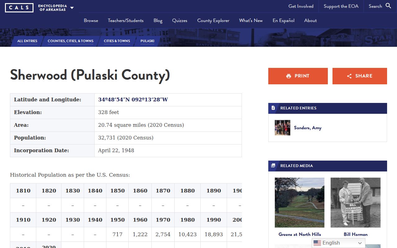
The local history source supplies the place-name bridge that turns an apparent dead end into a new index heading.
Koehler Lane's Sherwood Address Story
Koehler Lane offers a concrete house-history model. The local history identifies 829 Koehler Lane, built for Paul Koehler in 1927, as probably the oldest surviving home within Sherwood's original city limits. Descendants of the Koehler family have remained linked with the lane. That does not remove the need for source checks. It shows how one named place can connect a historic account, the present parcel, deeds, family evidence, and dated directories.
Begin with today's assessment account and legal description. Work the deed chain backward, then test the historic narrative against directories and the 1930, 1940, or 1950 census as access and geography permit. Since the house predates Sherwood's incorporation, rural Pulaski County and North Little Rock-oriented indexes deserve attention. Each source should keep its own date and role label.
This is also a warning against using a famous address as a template for every property. The research did not locate a Sherwood-specific house-history guide or a verified Sherwood run of Sanborn fire-insurance sheets. Search broader repositories where relevant, but do not claim coverage that has not been confirmed.
Roundtop Links Sherwood Records
Roundtop Filling Station demonstrates how several record types can meet. Built in 1936, it entered Sherwood through the 1975 Trammel Road annexation. It later passed through an owner's estate before heirs donated it to the city in 1999. The documented sequence joins a physical site, boundary change, ownership, probate, heirs, donation, and preservation.
For a private house, the same pattern starts with a deed and legal description, then follows probate only when a deceased owner's estate is relevant. A successor deed can confirm what happened to the land. An obituary can add family context, but names in an obituary should not automatically be labeled legal heirs. The filed probate record controls that question.
Public records can explain transfer and context without revealing every past occupant. That restraint is part of a reliable previous-residents search.
Date Sherwood Houses with Permits
Sherwood permit files can date construction, additions, repairs, and named participants. The residential application asks for a construction address, project or business name, contractor, and one combined ownership or occupancy field. Preserve the ambiguity. The form does not let a later researcher decide which role applied without corroboration.
Ask Sherwood Engineering, Permits & Planning for the address file or submit a narrow FOIA request with the exact address, record type, and date range. No complete public online permit index or exact start year was verified. A permit can date a change to the house, but it cannot establish continuous occupancy or every prior resident.
Note: Preserve an applicant's stated role because a permit name may belong to an owner, occupant, contractor, or project contact.
Close Sherwood Previous Resident Trails
Probate, obituaries, and successor deeds can explain why a name disappears from an address. Pulaski probate files may name a decedent, personal representative, heirs, addresses, and property, depending on the filing. Historic probate packets extend back to 1819 in archival collections, while Pulaski coroner inquests cover 1865 to 1903. Current probate access runs through the circuit clerk and public court index, subject to confidentiality rules.
Use the filed instrument to identify legal roles. An obituary is a strong lead for relatives and dates, but it is not a court order. After a death, search the deed index for an estate, personal representative, heir, or later grantee tied to the same legal description. This can explain the next title event without claiming a private present location.
The Roberts Library Research Room also provides newspapers, obituary resources, microfilm, and genealogy databases. The genealogy desk is an access fallback when a name is absent online. Arkansas State Archives offers catalog and research channels for older county material, though its assigned screenshot failed and is not shown.
Limits on Sherwood Previous Residents
Past occupants and past owners are not the same group. A deed chain misses renters and many household members. A directory may omit a person, use an older place name, or freeze an address at publication. Census schedules stop at the latest public release. Permits describe work. Probate and obituaries apply only when those life events occurred and can be found.
Some records must remain closed. Protected voter addresses, DMV personal data, sealed court files, adoption records, current vital records, confidential military discharges, and private utility customer data have legal limits. An official dead end should remain a dead end. Do not guess around a protected record or use a historic trail to track a living person.
Lawful use. Use Sherwood past-resident research for house history, family history, estate work, or personal curiosity. Never stalk, harass, intimidate, or harm a living person.